Page 1 of 3
Interface description
Upon opening, QGis uses the parameters stored into the QRex file (a QGis project file)
By default some layers are present into the project, although of course they are empty at the beginning, and the user has the possibility to modify the list of layers.
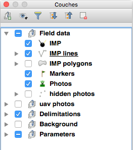
Layers in QRex
They are organized in groups :
- The group of field markers:
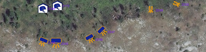
- IMP: the main "Indicator of Mine Presence" (or Absence) layer. It is a point layer, meaning that any object located on the field will be represented by a point symbol.
- IMP-line: Indicators can be represented as lines (trenches, roads, walls, …). The geometry used for these is a line string.
- IMP-polygon: for Indicators delineated as polygons, like terrain features.
- Markers: a point layer for markers that are not Indicators related to mines like the IMPs but to landmarks, warning signs, and so on.
- Photos: a point layer storing the location where photos were made on the field and presenting these photos.
- hidden photos: same as previous but normally containing photos hidden from the canvas, to not clutter up the display
- The group of Area delimitation:
- Areas: a polygon layer displaying the areas of interest for the data collection or the demining activities.
- The user is free to add any kind of delimitations available (like administrative delimitations, for instance)
- Background group: here background images or map servers can be inserted, depending on the needs, like aerial images, road network, land cover, OpenStreetMap, and so on.
- Parameters group: here are all the parameters tables needed for QRex. Do not remove them unless you know what you are doing. These tables are editable directly in QGis if the user has the privileges to do so, according to the user accounts in the database.